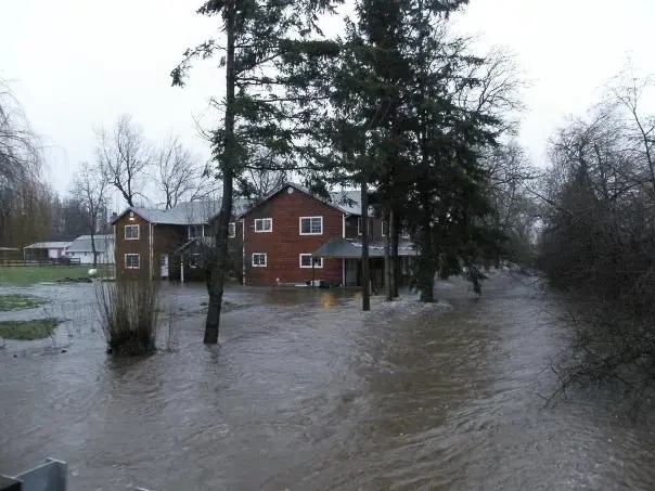
Arlington, Washington, sits on the Stillaguamish River, with downtown on a bluff above the confluence of the river and its North Fork and South Fork. Snohomish County's flood table for the Arlington gauge gives homeowners numbers to watch: minor flooding at 14 feet and major flooding at 19 feet. The river reached a record in December 2023 and came close to it again in December 2025.
Key takeaways
- At the Arlington gauge, Snohomish County lists minor flooding at 14 feet and major flooding at 19 feet.
- At 19 feet, deep, swift water floods many roads, including Pioneer Highway, Highway 530, Marine Drive and Norman Road.
- The river reached a record 21.34 feet on December 5, 2023, more than seven feet above flood stage.
- Once river water is inside, it is Category 3: soaked carpet, pad and drywall are removed, and the structure is cleaned and dried.
- Whether a policy pays depends on its wording, and a record of photos and daily logs helps either way.
Reading the Arlington gauge: 14, 19 and 20 feet
Arlington gets about 46 inches of precipitation a year, and November and December are the wettest months, each averaging about 6 inches. A forecast gives a height, and the county's flood table says what that height does.
Where the river meets the city
Downtown Arlington is on a bluff above the confluence of the Stillaguamish River and its North Fork and South Fork. Most of the city lies in the watersheds of the Stillaguamish River, Portage Creek and Quilceda Creek.
Arlington Bluff is a residential area between the Stillaguamish River floodplain and the industrial center around Arlington Municipal Airport. The county table does not say which Arlington addresses flood, so the gauge number is the one to watch.
Minor flooding at 14 feet
The county's flood table for the Stillaguamish River at the Arlington gauge lists minor flooding at 14 feet.
Major flooding at 19 feet
At 19 feet the county says deep, swift water floods many roads, including Pioneer Highway, Highway 530, Marine Drive and Norman Road. Residential areas near Silvana, Norman, Florence and Stanwood flood as well.
Levees at risk at 20 feet
At 20 feet the county says water covers Highway 530 east of Arlington and at Island Crossing, and levees are subject to overtopping and damage.
Records, and what December 2025 added
The river at Arlington reached a record 21.34 feet on December 5, 2023, more than seven feet above flood stage, according to Snohomish County Emergency Management. The Seattle Times reported that the previous record, 21.16 feet, was set in 2010.
In December 2025 the City of Arlington posted flood alerts on December 5, 8 and 10. The city's December 10 alert gave a forecast of 23.75 feet for that night.
Reports afterward on the December 2025 floods said the Snohomish, Skagit and Cedar Rivers set all-time records while the Stillaguamish fell just short of its record high. The Associated Press photographed a home surrounded by flood water near Twin Rivers Snohomish County Park in Arlington on December 11, 2025.
The reports did not give the crest the river reached at Arlington in December 2025.
What river water does inside a house
River water carries silt, runoff and sewage, so it is Category 3 the moment it comes inside. It cannot be cleaned and left in place.
Flood water cleanup removes what the water soaked and cleans what it only touched.
Hard materials such as concrete, tile and framing can be cleaned and dried. Soft materials that soaked, such as carpet, pad and insulation, are removed.
- Carpet and pad: removed.
- Drywall and insulation: cut out to a safe height above the high-water mark.
- Cabinets and trim: pulled when they soaked.
- Framing and subfloor: cleaned, then dried.
First steps when river water reaches the house
Moving water is dangerous, and standing flood water can hide hazards. It can also carry sewage, so boots, gloves and careful hand washing matter.
- Leave the house if the water is rising, and never walk or drive through moving water.
- Switch off power only from dry footing, and stay clear of wet outlets and cords.
- Take dated photos of the high-water mark in each room before anything is moved.
- Lift small furniture and papers above the water only if that is safe.
- Leave removal of carpet and drywall to the crew, who wear protective gear.
Drying after river flood water
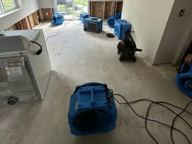
Water extraction comes first, since pumps remove liquid faster than dehumidifiers pull vapor.
Structural drying then runs on daily readings, and the equipment leaves only when framing is within 2 to 4 points of the dry reference.
November and December are Arlington's wettest months, so outdoor air gives little drying help and the equipment does the work.
Wet wood and drywall can begin to grow mold after 24 to 48 hours, which is why drying starts right after the water is out.
Flood maps, insurance and records
The City of Arlington adopted updated Digital Flood Insurance Rate Maps from Snohomish County and FEMA in June 2020.
Whether a policy responds to river water depends on its wording, so the insurer or agent is the one to ask. Report the loss early, because notice rules and deadlines vary by policy.
An adjuster works from the file, and Arlington water damage restoration builds it from the first visit: photos, a moisture map and daily drying logs.
- Photos or video of the water in each room, taken before cleanup begins
- The water category and loss class from the first visit
- A list of removed materials, with rough ages
- Moisture readings for every day of drying
Getting ready for the next high water
The City of Arlington has posted flood alerts as the river rose, and the gauge numbers make those alerts easier to read.
- Know the gauge levels: 14 feet is minor flooding and 19 feet is major.
- Make sure the main water valve and the breaker panel can be reached without crossing wet floor.
- Move valuables above floor level in ground-level rooms before a forecast crest.
- Take photos of each room and its contents ahead of time, so there is a baseline if a claim follows.
Questions
What flood level is serious at the Arlington gauge?
The county lists minor flooding at 14 feet and major flooding at 19 feet, when deep, swift water floods many roads and some residential areas.
What is the record on the Stillaguamish River at Arlington?
The river reached a record 21.34 feet on December 5, 2023. The Seattle Times reported that the earlier record, 21.16 feet, was set in 2010.
Which roads flood when the river reaches 19 feet?
The county names Pioneer Highway, Highway 530, Marine Drive and Norman Road, plus residential areas near Silvana, Norman, Florence and Stanwood.
Is flood water in a house Category 3?
Yes. River water carries silt, runoff and sewage, so porous materials it soaks are removed and the rest is cleaned, treated and dried.
Does homeowners insurance cover river flooding?
Not always. Whether a policy responds depends on its wording, so ask the insurer or agent before work goes past emergency steps.
How long will drying take once the river goes down?
The time depends on how much water got in and what it soaked. Equipment stays until readings reach the dry goal, and damp winter air can add days.